

Assasuni (Bengali: আশাশুনি, Aashashooni, Ashashuni, means hearing the hope ) is an upazila of Satkhira District in Khulna Division, Bangladesh. The Assasuni Upazila is one of the most vulnerable Upazila and stands at the forefront of the dynamics of climate change and development as shown in regional risk assessments. Therefore, this Upazila has been chosen for our action research with the communities and to deploy our agro-ecological experimentations in the fields with and for the farmers.
The Subdivision of Assasuni is a part of the South-West Bangladesh region, which includes the well-known Sundarbans mangrove forest. The Mangrove Forest functions as a crucial hub of land-water interaction, influencing the lives and livelihoods of about 3.5 million locals. The Munda community, as well as the Bawali (forest dwellers), Mawali (honey collectors), fishers, and subsistence farmers, make up the majority of the local communities and are reliant on traditional resource-based activities for survival.
However, the intricate interaction of variables, frequent cyclones causing saline intrusion, and riverbank erosion, has caused significant disruptions in the fabric of local livelihoods. Additionally, the expansion of shrimp farming has made it easier for private shrimp land holdings to emerge, which has further changed the socioeconomic environment.
In order to address these issues, the SAJIDA Foundation and ULAB have joined forces, concentrating particularly on the Pratapnagar Union in the Assasuni Upazila. The foundation of this innovative project is the idea of climate-resilient integrated farming, which aims to provide communities with long-lasting solutions. The project seeks to strengthen the community through novel methods like rainwater collection, the use of salt-tolerant seed varieties, and the resurgence of indigenous knowledge. Resilience in the face of climatic uncertainties.
The project’s core objectives extend beyond immediate relief, seeking to establish a foundation for holistic and adaptive development. By harnessing the potential of integrated farming practices, it endeavours to mitigate soil salinity, ensure consistent agricultural productivity, and uplift the socio-economic well-being of the local populace. With a multi-modal approach blending traditional methods, participatory engagement, and innovative technologies, this initiative represents a crucial step towards nurturing a resilient ecosystem that can effectively navigate the challenges posed by climate change.
Assasuni Upazila is divided into 11 union parishads: Anulia, Assasuni, Baradal, Budhhata, Durgapur, Kadakati, Khajra, Kulla, Pratapnagar, Sobhnali, and Sreeula. The union parishads are subdivided into 143 mauzas and 241 villages.[3]
The Upazila is located between the rivers Marichchap, Kholpetua, Betna and Kopothakkho.
As of the Bangladesh census, Assasuni had a population of 220,957 in 1991 and 268,754 in 2011 (2011 Bangladesh census,). Muslims formed 72.94% of the population, Hindus 26.46%, Christians 0.50% and others 0.10%. Assasuni had a literacy rate of 30.3% (7+ years) in 1991 and 49.83% in 2011 for the population 7 years and above.[1]
Multiple disruptive hazards and production of risks
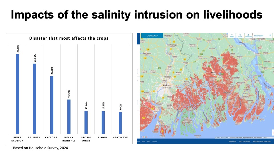
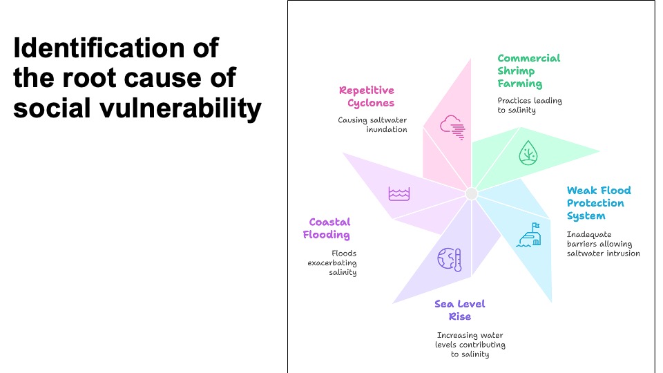
Studied community are facing multitude of disruptive hazards stem from climate change, environmental degradation and human intervention. The studied community has been facing acute salinity intrusion resulted from sea level rise, intensified and repeated cyclones and costal flooding. Coupled with human intervention such as commercial shrimp farming, water management and other development activities the local community is facing significant environmental degradation, interruption of ecosystem services and shrinking economic and livelihood opportunity.
Situated adaptive practices
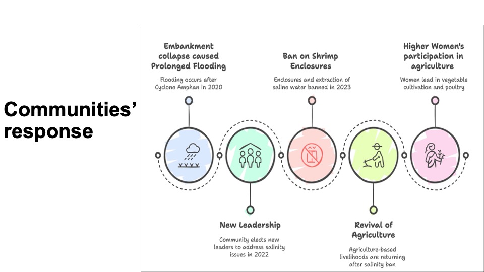
Following a devastating flood that submerge the study area for nearly two years as an aftermath of super cyclone Amphan in 2020, the studied community reinvigorated their effort for systematic change in local governance that they believe is the key to build resilience against the multiple disruptive risks. Commercial shrimp farming inside the flood protection polder area is perceived as a major catalyst for increased salinity intrusion, weakening flood protection and shrinking livelihood. Social, political and institutional relationship and use of natural resources in study area are heavy influence by shrimp farming and associated activities.
Banning shrimp farming using electoral system
In 2022 commercial shrimp farming become electoral issue during local council election campaign. Incumbent chairperson of local council perceived as pro shrimp farming by local community and the opposition centered their campaign on shrimp banning policies. Opposition won the election in a landslide and banned shrimp farming inside and close all saline water carrying cannels which is a prerequisite for shrimp farm. There is still a strong consensus among communities against shrimp farming especially within in flood protection polder area.
Reviving Agriculture
Following the banning and changed attitude towards shrimp farming, community members are reclaiming their land for agriculture activities. The land still has significant salt presence and any kind of agriculture is still difficult. Apart from salt presence, irrigation for rice and another agricultural crop remain challenging as irrigation infrastructure are development yet and support market linkage is week. However, farmers are applying traditional knowledge to reduce salinity from land. Efforts include applying sugar, taking out top layer of the soil, washing land repeatedly with fresh water when water available, and plating different type of crops simultaneously to see which grows better. Many farmers have reported that they have brought back a long-lost rice variety locally known as “Tacshail” that can withstand heavy saline and help reduce salinity from soil.
")
